Trivia of compasses
■ Let's learn basics of how to use compasses how to use
・I will turn a body to the north

As for the compasses, red of the needlepoint sets out for the north.
The zero degree (▼ seal) of the rotary board becomes the top.
The compasses do it in the front of a body and have with high heart horizontally.
I turn the body remaining it with compasses, and the front of the body turns to the north if needlepoint matches zero degree (▼ seal).
The zero degree (▼ seal) of the rotary board becomes the top.
The compasses do it in the front of a body and have with high heart horizontally.
I turn the body remaining it with compasses, and the front of the body turns to the north if needlepoint matches zero degree (▼ seal).

The compasses of the left-hand figure are products called the field school for children.
The direction of the zero degree means the north.
All compasses work assumes magnetic north zero degree and express it at the frequency clockwise.
In other words, 90 degrees will show the west if east, 180 degrees are south, 270 degrees.
It becomes easy to understand this when getting used.
The direction of the zero degree means the north.
All compasses work assumes magnetic north zero degree and express it at the frequency clockwise.
In other words, 90 degrees will show the west if east, 180 degrees are south, 270 degrees.
It becomes easy to understand this when getting used.
・Let's check the direction that we want to go

I will choose the place (destination) that wants to go somewhere if I can match it with a map.
I can check the angle to the destination in a map if I know a place (the present location) that there is now.
I can check the angle to the destination in a map if I know a place (the present location) that there is now.
1.I draw a line in destination ◯ from present location △. I match compasses with the line like right figure ①.
2.I turn a rotary board, and the zero degree (▼ seal) of the rotary board matches the needlepoint as it is. (figure (2))
The direction that I wanted to go in this was set.
3.I will separate compasses from a map.
I put the map away. There is the destination in the direction that the body turns to if I do compasses in the front of a body, and durability, zero degree (▼ seal) and the needlepoint of the rotary board are correct suddenly. (figure (3))
■ Can do it using compasses
・Method to know the rough time

I check zero degree (as for the product of the right figure ▼ seal) in the direction of the sun.
The number that divided the angle of the needle for the finger pinpoint (the north) of compasses by 15 from zero degree becomes at approximate time at the present.
The right figure sets out for the direction of 240 degrees. The sun and the north angle to do are 120 degrees.
It is 120 ÷ 15 = 8 that is 8:00.
This is a method using the sun moving about 15 degrees in one hour.
(but you must calculate the north as 0:00 a.m.)
It may slip off for approximately one hour by a season.
・Method to know the direction using a watch

I build a stick in perpendicular (straight) in the point of the hour hand of the watch. I turn a watch to have the shadow and an hour hand coming at the same time. A position of 12:00 and the middle of the hour hand become the south direction.
I point an hour hand that I level a watch to the sun.
The middle of the scale that a position and the hour hand of 12:00 point at becomes the south.
Therefore, the objection comes to face north.
I think that it is easy to measure it when I put the hour hands of the clock together to the shadow of the thing which puts up a thin stick earlier, and makes a shadow, or stood perpendicularly of the hour hand to check a direction a little more exactly.
Please check it by all means.
・Method to know the north from the shining star
It is too famous that a direction with the polestar says the north, but it is unexpectedly difficult to distinguish it in a star shining in the night sky which is the polestar.
I can find the polestar near ladle-shaped Big Dipper (a part of the bear seat) and W-shaped Cassiopeia.
Because the position such as the figure has a relation, please look for these stars in news.
As for the Big Dipper, the summer night sky can see Cassiopeia on the head of the winter night sky from autumn from spring. As these two constellations see either anytime, I can look for it anytime if it clears at night.
If the polestar is found, the bottom is a north direction.

| I see many stars in the clear dark night sky of the air. I can see it distantly to the remote sixth prize star. However, I see it only to not more than second class star near the bright city. Because polestar and Big Dipper and Cassiopeia are meetings of the second class star, I can say that it is the star which it is easy to relatively look for in the city. |
・I measure the strength of the battery

As shown, I wind a lead around compasses 1 round and am connected to the battery. A difference greatly leaves for the movement of the guideline by a strong battery and the weak battery.
I can distinguish a strong battery and a weak battery in this way.
I can distinguish a strong battery and a weak battery in this way.
■ Story of the earth
・The earth is a huge permanent magnet.
Because the earth becomes the magnet, compasses are usable.
Then, that means, there is a liquid (magma) of 6,000 degrees Celsius based on iron which is a transmission body inside of the earth whether it becomes the magnet, and because the earth rotates, I come off internal rumbling sounds and the liquid which did it in a center and a surface section, and the earth which is why moves.
It becomes difficult, but then a thing composed primarily of iron is to rub, and to turn, and a thing named the faradism occurs in a magnetic field. If an electric current flows in a magnetic field, a magnetic field is completed, and the whole becomes the magnet because this phenomenon takes place in the earth.
Such reason is like a certain conclusive evidence opinion.
There is S pole in the North Pole when I think simply, and the guideline of compasses points to the constant direction because there is N pole in the geographical south pole.

| As shown, a line of magnetic force overturns over the earth. In the case of the earth, I call this geomagnetism. Because the compasses placed on the earth stop along a line of magnetic force, the N pole of compasses turns to the north. |
The compasses turn to where in ・ North Pole
It seems to be in a problem of the science of the elementary school, but the correct answer "turns to the bottom"
I seem to understand that this looks at the figure, but surround it around the earth
The geomagnetism greatly goes around the outer space from the South Pole and is contained in the North Pole.
The horizontal component force of the geomagnetism vector we as the north and south
I recognize it. (there is actually the vertical component force on the earth surface, too
The horizontal component force on the North Pole of) magnetic force doing disappears; a flow of the geomagnetism
It becomes the ha vertical direction. In other words, it is muki or now in the other side that ran through the earth
Do. Therefore the compasses look down for the middle.
■ The north (magnetic north) that the axial north (due north) and magnet of the earth set out for
・Did you know that you did not point to the north?
There is the true north on the axial top where the North Pole, the earth rotate. As for the map, as for the thing with a ball as a plane, all maps, the north becomes the top.
However, the north (magnetic north) that compasses set out for does not fit the North Pole (due north). It slips off only a little. This does not have compasses upset, and all compasses can happen under characteristic influence of the earth.
However, the north (magnetic north) that compasses set out for does not fit the North Pole (due north). It slips off only a little. This does not have compasses upset, and all compasses can happen under characteristic influence of the earth.
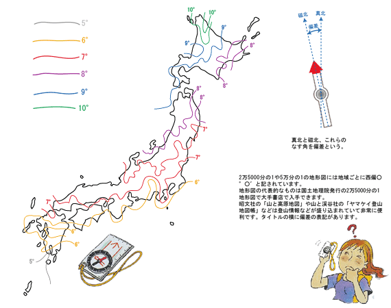
■ Figure of deviation of Japan
I stop at the approximately 5 degrees - 10 degrees west in Japan how long it slips off in Japan. In other words, there is the true north six times in the same way in the direction of five times in Kagoshima in Tokyo 9 degrees direction to the east from the magnetic north that compasses set out for in Sapporo; is different.
Magnetic variation is put on a map of the Geographical Survey Institute issuance by all means. For example, "50 minutes are written, and, in the magnetic north, they mean that they are partial 6°50' than due north west radical of a Chinese character six times" to the west. It is necessary for, in other words, 6°50' to hardly see all fifty-60ths plus as seven times not 6.5 degrees for sexagesimal system six times how many times in the point to be careful about in how many minutes.
Magnetic variation is put on a map of the Geographical Survey Institute issuance by all means. For example, "50 minutes are written, and, in the magnetic north, they mean that they are partial 6°50' than due north west radical of a Chinese character six times" to the west. It is necessary for, in other words, 6°50' to hardly see all fifty-60ths plus as seven times not 6.5 degrees for sexagesimal system six times how many times in the point to be careful about in how many minutes.
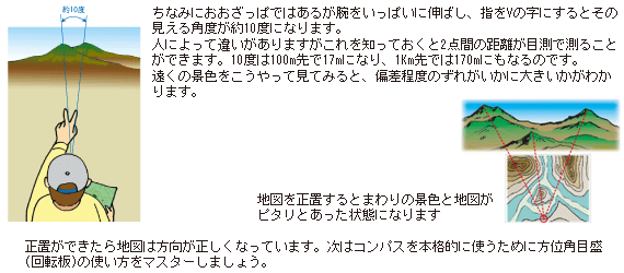
You do not need the deviation correction if you play in a field, but must read this deviation when you do positioning exactly. Otherwise I cannot match it with compasses even if I do it with a correct map. Then I will actually explain how to use compasses which comprehended a deviation using orienteering compasses.
Compasses are the tools which are the briefest to know the direction, but the orienteering compasses which it is easy to use it by an action of the outdoor, and a direction can easily set are suitable. The measurement that is close as the scale of the rotary ring is 2 degrees chopping fine is possible.
I think that it is easy to understand that you can read while opening it if there is a map, and practicing it.
Then I explain how to use.
Then I explain how to use.
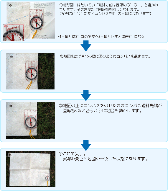
■ At first let's begin it because we put a map definitely
The basics in ・ basics appropriately place it
"I appropriately place it" is to put a map definitely self-evidently. Wide on a mere map; when is, and put it, do not agree with the real north and the north (on a map) of the map. It is called appropriately placing it to make this agree using compasses.
・ method is very easy
■ Right way of holding compasses
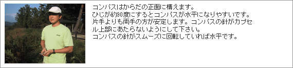
The use of ・ compasses is greatly three
1. I check it on confirmation, the map of the aim direction and go to the direction
2. I check confirmation ... sign thing of the aim thing seeing on a map
3. I check where you are in confirmation ... map of the present location
It is above-mentioned three when I greatly distribute it.
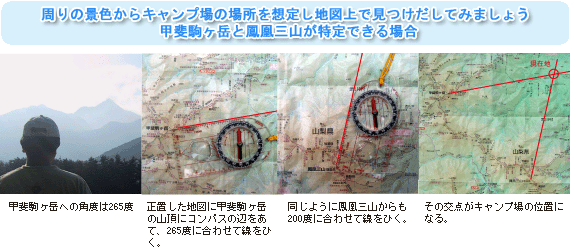
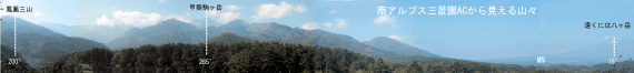
When I know both the present location and the destination on a map, the present location can produce the direction of the destination with ○° with a number. I can go ahead from the place to the direction even if it does not show a destination. In addition, I can check the name of the mountains surely when I faced magnificent scenery while traveling. I can confirm the place where oneself is when I lose sight of the present location if I repeat these things.
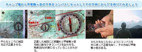
1.2.3 explains o based on real scenery as follows from the automatic campground of the Southern Alps.
2. I check confirmation ... sign thing of the aim thing seeing on a map
3. I check where you are in confirmation ... map of the present location
It is above-mentioned three when I greatly distribute it.
When I know both the present location and the destination on a map, the present location can produce the direction of the destination with ○° with a number. I can go ahead from the place to the direction even if it does not show a destination. In addition, I can check the name of the mountains surely when I faced magnificent scenery while traveling. I can confirm the place where oneself is when I lose sight of the present location if I repeat these things.
1.2.3 explains o based on real scenery as follows from the automatic campground of the Southern Alps.
1.I will input the direction to confirmation, the place to go to of the aim direction into compasses
(1) I perform it in a beginning to appropriately place.
(2) It merges the side of compasses with the present location to put on the map at the destination. I turn a rotary board so that N matches the magnetic needle tip of compasses (it is easy to be revealed that I draw a line at the present location and the destination). An angle of this time becomes the angle to the destination.
(3) I separate compasses from a map suitable for an aim and have compasses definitely and stand. I turn a body so that N of the rotary board matches the magnetic needle of compasses. I put a destination on the front direction from one of this time.
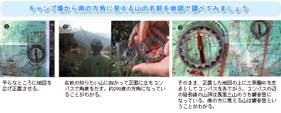
2.I check what the name of confirmation, that heap of aim things is
(1) I perform it in a beginning to appropriately place.
(2) I have compasses suitable for an aim definitely and turn a body to the heap of signs. Put magnetic needle tip of compasses and N of the rotary board together and demand the point of view.
(3) I put compasses on the map which I appropriately placed. I cover the present location of the map with the side of compasses. There is the mountain of the aim on the side where I turn the compasses body around the present location, and magnetic needle tip of compasses and N of the rotary board just matched.
3.I check the place where there is confirmation, oneself of the present location
When 1.2 steps on no step, I think whether you already know it. It can be determined by the above-mentioned application. I calculate two points of angles showing and input it into a map. The prediction of the present location runs out if I demand the point of intersection.
(1) I perform it in a beginning to appropriately place.
(2) I turn a body to the mountaintop (mountain understanding the name on a map) that oneself suitable for an aim can judge and start the angle.
(3) I put compasses on the map which I appropriately placed to write on the map. I cover the mountaintop (aim) in the topographical map with the side of compasses. It runs over a line in the place where I turn the compasses body around the mountaintop (aim), and magnetic needle tip of compasses and N of the rotary board matched. I repeat work of (2) (3) with the same point in search of (aim) including other mountaintops and demand a point of intersection. This is the present location.